
December 27. 2011
1130:01z
UNISYS Water Vapor North and West Hemisphere Satellite
Twelve hours earlier at the beginning of the 12 hour loop it is noted there are primarily straight line winds, but, only when the denser air mass reaches warmer land does the air expand and take up more space dictating a piling up of the mass into a vortex as seen developing quickly within the next 12 hours of the loop.
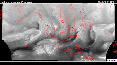
December 27, 2011
2230:01z
UNISYS Water Vapor North and West Hemisphere Satellite (click title to entry for 12 hour loop - thank you)
 December 28, 2011
0005 GMT
Pacific Coast Satellite
- Winds will be especially strong (click here) near the Washington and Oregon coasts, across south-central Oregon and over much of Montana and Wyoming with gusts from 40 to 75 mph.
- Lows will range from between 0 and 20 degrees in the central and southern Rockies to the 40s along the West Coast.
There seems to be a fair amount of moisture with this air mass, but, there is approaching straight line winds behind the developed vortex. I just don't like it. Probably much ado about nothing. I just worry about the high velocity winds, especially in the mountains where people, young people, could be spending their time off from school.
2312 GMT
Pacific Ocean Satellite
It isn't the usual vortex. This air mass has an etiology of completely arctic air. It is dense in concentration and it will carry more velocity with that density.
The approaching air mass picked up moisture from the some Indonesian rainforests and an Indian Ocean typhoon, but, quickly diverged into north and south directions.

1835 GMT
Pacific Global Satellite
The distinctive two masses are noted with the southern mass moving sharply south toward Antarctica. It is east of Australia and New Zealand, but, there is a small air mass noted to be moving over New Zealand. They just had another set of earthquakes this past weekend. The fun just never ends in New Zealand these days and there appears to be a burgeoning area of Christchurch which is unretrievible due to the continued shaking. I think this past weekend was nearly 6 on the Richter scale.

2214 GMT
Western Pacific Satellite
The heat transfer system from the Indian Ocean and Indonesia has substantial heat. It looks like northern Australia and New Zealand is its path.
But, the northern air mass that is at the west coast of North America is primarily from the west coast of India. It is considerably more north than the southern hemisphere air mass. It enters frigid territory quickly and accumulates condensation of water as it comes across the Pacific.

December 27, 2011
1710 GMT
Indian Ocean Satellite
The air mass that is providing the water vapor to the current west coast system of North America is actually a Tropical Storm which is still active. It is Tropical Storm Thane expected to make landfall across the southern end of India and passing over Sri Lanka.

December 27, 2011
2232 UTC
Graphic provided by Naval Pacific Meteorology and Oceanography Center/Joint Typhoon Warning Center (click here)

KOCHI, DEC 27:
As expected, the Bay of Bengal has erupted suddenly with activity after tropical cyclone ‘Thane' spun up over the waters early on Tuesday morning.
An Insat cloud imagery showed convective (rain-triggering) clouds rising over parts of Tamil Nadu, south and central Bay of Bengal and Andaman Sea
.
.
Meanwhile, a weather warning issued by the IMD said that heavy rainfall would break out at one or two places over Andaman and Nicobar Islands and over north coastal Tamil Nadu, Puducherry and south coastal Andhra Pradesh from Wednesday.
Meanwhile in the north, dense fog conditions have been forecast over parts of Punjab, Haryana Delhi Uttar Pradesh and Bihar until Thursday morning.
The prevailing cold wave would set off ground frost over many parts of Punjab, Haryana and Delhi and some parts of north Rajasthan and west Uttar Pradesh.