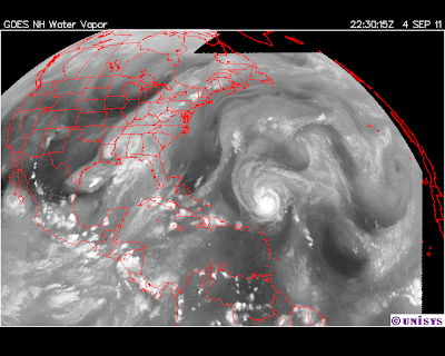
Monday, September 05, 2011

With Lee reorganizing and moving fast up the east coast...

September 5, 2010
2030.13z
UNISYS Water Vapor GOES East Satellite (click title to entry for 12 hour loop - thank you)

...I would not expect Katia to continue to remain on the same trajectory.


I tuned in and out of the Republican debates.  They were the same as they always are, full of 'mind speak' and 'rheotric,' 'fire and brimstone.'  Nothing of substance and always disregarding the USA after 1776 and instilling fear,  it is a safe place for the economically  illiterate.


1 injured in possible tornado in Cherokee County  (click here)


WOODSTOCK, Ga. (AP) - Authorities say one person was injured in a possible tornado in Cherokee County as the remnants of Tropical Storm Lee crossed the state.
Lt. Jay Baker with the Cherokee County Sheriff's department said the storm toppled trees Monday afternoon and several trees landed in homes. He said the victim was taken to the hospital but the person's condition is not known.
Weather officials say much of north Georgia is being hit with heavy rains and strong winds as the storm system moves through. Most of the state was under tornado and flood watches starting Monday afternoon....
There is this really great Lucas Marathon on today.  Good stuff.  Later.

It really is a very ugly picture when one reflects on the temper tantrums of the wealthy.


Billionaire tea party tycoons financed Wisconsin’s anti-union governor, records show (click here)

By Stephen C. Webster
Saturday, February 19th, 2011 -- 9:49 pm


Who were among the financiers behind Wisconsin's Republican Governor, now embroiled in a controversial attempt to destroy public sector unions?
None other than reviled tea party financiers Charles and David Koch, is who.
Turns out, the billionaire oil tycoons' political action committee gave Gov. Scott Walker (R) roughly $100,000 in campaign contributions during the 2010 election, according to campaign finance records highlighted by  Mother Jones.
The contributions came from the same source -- Koch Industries PAC -- and though through two channels which were both legal under current campaign finance law….
Ill mannered bunch of brats that throw out the USA Brain Trust for their greedy goals.


Engineered by desperate wannabe million-billionaire, now Chairman of the RNC.  


Anyone surprised how completely dysfunctional the Republicans are and remain?  


And back by Dirt Bags.  How can they lose?  It is a coupe against the government.  No one will convince me otherwise.  They are dismantling the 'national conscience.'

The "Near Shore" Phenomena started to really make itself known about 1999.

1999 Storm Track of Hurricane Dennis


It came inland and then went out to sea only to return to an inland presence.


Shortly after that in the very same spot that Dennis liked so much a whopping hurricane by the name of Floyd would make its presence.


1999 storm track of Hurricane Floyd.


Then it would be in 2002 when Kyle would make a visit in a similar pattern.  Oddly, though when Kyle left its 'offshore' run it dissipated out at sea in less than 24 hours.


2002 Storm Track of Kyle. 


It would be 2 years later, in 2004, when near shore storms would dominate the Atlantic hurricane season.

The 2004 Hurricane Season.


Alex and its beginnings near shore and then went out to sea, Charly began in the Caribbean and then hugged the eastern seaboard and Gaston was similar to Alex in its pattern.

The 2005 hurricane season would be the 'maximum' for 'the normal' hurricanes with record setting numbers and 'seasonal velocities.'  


After 2005 the water vapor moved from the surface of Earth to a higher altitude and the 'character'of the hurricane changed to something far less 'normal.'  2006 was a year of transition with very few storms and the only major storms would stay at sea where they had fuel.


2007 Storm Track of Hurricane Gabrielle.

In 2007 the only hurricane the continental USA would realize was Gabrielle.  Its presence to inland was ONLY near shore.


2008 would see two near shore storms Fay and Hanna.  Fay would have a pattern somewhat similar to Katrina but not close to exact.  Hanna was nothing but near shore.


2008 Storm Track of Fay


2008 Storm Track of Hanna.


2009 did not see any major storms that would effect the continental USA.  Again repeating a pattern between 2005 and 2006, but, with far lower 'seasonal velocities.'


2010 had only one major hurricane to touch the USA and it was a near shore storm called Earl.


2010 Storm Track of Earl.


That brings us to 2011 and the current dynamics with Lee and Katia are more than disconcerting.


Katia and Lee manifested after Irene produced huge amounts of water vapor delivered to a very hot troposphere.  Their relationship is indelible and quiet frankly I do not believe the relationship is over.  As Katia moves closer to shore it will benefit from the water vapor that Lee has deposited in the troposphere which makes its dynamics more than curious.


Have a better day.

Tha National Hurricane Center needs more personnel on duty. People are really stupid to vote for Republicans. They are a do nothing party catering to their wealthy financiers.

September 4, 2010
2230.15z
UNISYS Water Vapor GOES East Satellite


Interesting statistics on the Lee-Katia dynamic, but, Katia is only being measured every six hours.  That's not good.


People need to complain about the underfunding of their government, it shows.


Below are the statistics regarding the two storms.  Kindly note the central pressures.


LEE

 11  29.60  -92.50 09/04/09Z   40   987 TROPICAL STORM
11A  29.70  -92.00 09/04/12Z   40   986 TROPICAL STORM
 12  29.90  -91.90 09/04/15Z   40   986 TROPICAL STORM
12A  30.40  -91.80 09/04/18Z   40   987 TROPICAL STORM
 13  30.60  -91.80 09/04/21Z   40   987 TROPICAL STORM
13A  30.90  -91.80 09/05/00Z   35   989 TROPICAL STORM
 14  31.00  -91.40 09/05/03Z   30   990 TROPICAL DEPRESSION


September 5, 2011
1130.13z
UNISYS Water Vapor GOES East Satellite (click title to entry - thank you)

The time mark 09/04/09z for both storms show two tropical storms with Lee's central pressure actually lower than Katia.

At time mark 09/04/12z which is three hours later for Lee.  (Each time mark is NORMALLY 3 hours apart to monitor the severity of the storm.)  But, for Lee there was  a millibar of change in pressure of 1 to 986 milibars.  That continued through time mark 09/04/15z.

In the same time marks in Katia there were alarming changes.

Katia
 
 25  21.40  -58.50 09/04/09Z   60   992 TROPICAL STORM
 26  21.90  -59.20 09/04/15Z   85     - HURRICANE-2
 27  22.70  -60.10 09/04/21Z   90   965 HURRICANE-2
 28  23.40  -61.00 09/05/03Z   90   965 HURRICANE-2
 29  23.90  -62.00 09/05/09Z   85   972 HURRICANE-2

At time mark 09//04/09z Katia was a Tropical Storm at a central pressure of 992.  Six hours later, not three hours, but six hours at 09/04/15z Katia had dropped its central pressure 
with no record made, but, its winds escalated 15 mph to 85 mph.  

The entire transition of this storm at what normally would have been time mark 09/04/12z was missed.  At that point Katia would have been recorded and NOTED to be changing 
dyanmics quickly to a Cat 1 hurricane.

By the time central pressure measurements resumed at mark 09/04/21z the Cat 2 hurricane had dropped its central pressure by a whooping 27 millibars and Katia was now screaming in the Atlantic with a central pressure of 965 and winds of 90 mph AND A VERY CLEAR AND 
DISCERNIBLE EYE.

The reason this is significant beyond the negligence of proper funding for sufficient and
QUALIFIED personnel it that it clarifies the Climate Crisis dynamic of these huge storms.  To say this is more than obvious is important, but, to realize both storms dropped their central
pressures at the same time is hugely significant. 

THEY MOVE AS if ONE and that is DANGEROUS and a new prediction science, because the future holds storms on both coasts at the same time increasing dangers together.

Katia will have a similar pattern as Earl from the 2010 season.  FOR NOW.  

And to realize 'the sameness' of two seasons running is an important factor to 
note.